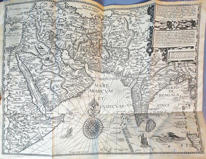
Linschoten Histoire de la Navigation
LINSCHOTEN, Jan Huygen van (1563-1611).
Histoire de la navigation de Jean Hugues de Linschot hollandois: aux Indes Orientales - Le Grand Routier de mer de Jean Hugues de Linschot hollandois. Contentant une instruction des routes & cours qui'il convient tenir en la Navigation des Indes Orientale.
Amsterdam: Evert Cloppenburgh, 1638.
12 1/4" x 8".
Comparable: Sotheby's, 2008 - $43,750.
Histoire de la navigation de Jean Hugues de Linschot hollandois: aux Indes Orientales - Le Grand Routier de mer de Jean Hugues de Linschot hollandois. Contentant une instruction des routes & cours qui'il convient tenir en la Navigation des Indes Orientales.- Description de l'Amérique & des parties d'icelle, comme de la Nouvelle France, Floride, des Antilles, Iucaya, Cuba, Jamaica, &c. 3 parts in one volume, folio. Titles of Parts I-II within elaborate engraved border, engraved vignette on title of Part III, engraved portrait of Linschoten, 6 engraved folding maps, including the twin hemispherical world map by J.B. Vrient after Petrus Plancius (Shirley 192), 32 (of 36) engraved double or folding plates, woodcut initials, head- and tailpieces, separate pagination for each part but with continuous registration. CONDITION/BINDING: Lacking Church's plates 7, 34-36 (cf. Church 252), Part I title-page tipped in, leaf A2 guarded, plates toned, world map slightly trimmed along bottom, long marginal tears to maps of the Coasts of Abyssinia, Arabia, and Hindostan and of South America and the Antilles, occasional light toning in Part II, strong damp staining and browning in Part III (quires Pp-Rr), lacking terminal blank. Eighteenth-century half speckled calf; rebacked with chips to spine and joint cracking near foot of spine, end papers renewed. (64V1A) The third edition with additional commentary on the historical and scientific aspects of the accounts by the physician and natural history collector Bernardus Paludanus, whose annotations are printed in italics. The present edition is virtually a line-for-line reprint of the first French edition of 1619 but is illustrated with the original plates from the first edition of 1595-96-95 published in Dutch (Church 252) rather than with the reduced engravings used in the 1619 edition. During his five years in Goa in the service of the Portuguese, Linschoten recorded the caste system and social customs of India as well as its flora and fauna. Divided into three parts, the first deals with the East Indies and Africa, including regions as far east as China and Japan. The second book delineates navigation of the coasts of West Africa around the Cape of Good Hope to Arabia. The third section is devoted to North America, including Florida, the Caribbean, and Brazil. REFERENCES: Alden/Landis 638/67; JCB III, P. 271; Palau 138584; Sabin 41373.
View it on
Estimate
Time, Location
Auction House
LINSCHOTEN, Jan Huygen van (1563-1611).
Histoire de la navigation de Jean Hugues de Linschot hollandois: aux Indes Orientales - Le Grand Routier de mer de Jean Hugues de Linschot hollandois. Contentant une instruction des routes & cours qui'il convient tenir en la Navigation des Indes Orientale.
Amsterdam: Evert Cloppenburgh, 1638.
12 1/4" x 8".
Comparable: Sotheby's, 2008 - $43,750.
Histoire de la navigation de Jean Hugues de Linschot hollandois: aux Indes Orientales - Le Grand Routier de mer de Jean Hugues de Linschot hollandois. Contentant une instruction des routes & cours qui'il convient tenir en la Navigation des Indes Orientales.- Description de l'Amérique & des parties d'icelle, comme de la Nouvelle France, Floride, des Antilles, Iucaya, Cuba, Jamaica, &c. 3 parts in one volume, folio. Titles of Parts I-II within elaborate engraved border, engraved vignette on title of Part III, engraved portrait of Linschoten, 6 engraved folding maps, including the twin hemispherical world map by J.B. Vrient after Petrus Plancius (Shirley 192), 32 (of 36) engraved double or folding plates, woodcut initials, head- and tailpieces, separate pagination for each part but with continuous registration. CONDITION/BINDING: Lacking Church's plates 7, 34-36 (cf. Church 252), Part I title-page tipped in, leaf A2 guarded, plates toned, world map slightly trimmed along bottom, long marginal tears to maps of the Coasts of Abyssinia, Arabia, and Hindostan and of South America and the Antilles, occasional light toning in Part II, strong damp staining and browning in Part III (quires Pp-Rr), lacking terminal blank. Eighteenth-century half speckled calf; rebacked with chips to spine and joint cracking near foot of spine, end papers renewed. (64V1A) The third edition with additional commentary on the historical and scientific aspects of the accounts by the physician and natural history collector Bernardus Paludanus, whose annotations are printed in italics. The present edition is virtually a line-for-line reprint of the first French edition of 1619 but is illustrated with the original plates from the first edition of 1595-96-95 published in Dutch (Church 252) rather than with the reduced engravings used in the 1619 edition. During his five years in Goa in the service of the Portuguese, Linschoten recorded the caste system and social customs of India as well as its flora and fauna. Divided into three parts, the first deals with the East Indies and Africa, including regions as far east as China and Japan. The second book delineates navigation of the coasts of West Africa around the Cape of Good Hope to Arabia. The third section is devoted to North America, including Florida, the Caribbean, and Brazil. REFERENCES: Alden/Landis 638/67; JCB III, P. 271; Palau 138584; Sabin 41373.


