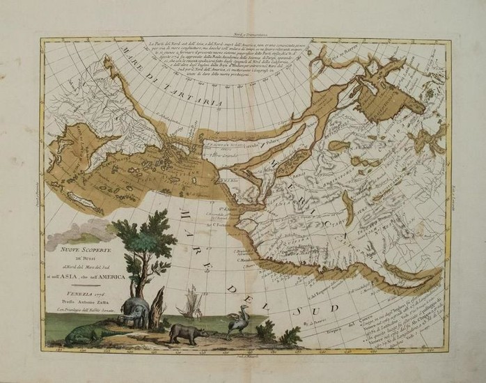
1776 Zatta Map of the North Pole to America -- Nuove
Title/Content of Map: 1776 Zatta Map of the North Pole to America -- Nuove Scoperte de' Russi al Nord del Mare del Sud si nell' Asia, che nell' America
Date: 1776 c., Venice
Cartographer: A Zatta
Size: 12 x 15.5 in.
This is an outstanding map showing from the North pole to much of Western (to Baja California) and Mid North America and parts of Siberia including Kamchatka.The map presents hypothetical cartography; Alaska is represented by a group of islands clustered off the coast of Russia, and the northwest coast of North America is filled with the fictitious system of rivers and lakes of the Northwest Passage and discoveries of Admiral de Fonte. There is a notation of the legendary land of Fou-Sang, here noted as a Chinese colony(translated to English)in the general area of what would become Vancouver Island in the Pacific Northwest. The pictorial title cartouche includes several incongruent animals - a crocodile, an elephant, a rhinoceros and an ostrich.
Reserve: $600.00
Shipping:
Domestic: Flat-rate of $20.00 to anywhere within the contiguous U.S.
International: Foreign shipping rates are determined by destination.
Combined shipping: Please ask about combined shipping for multiple lots before bidding.
Location: This item ships from Ohio
Your purchase is protected:
Photos, descriptions, and estimates were prepared with the utmost care by a fully certified expert and appraiser. All items in this sale are guaranteed authentic.
In the rare event that the item did not conform to the lot description in the sale, Jasper52 specialists are here to help. Buyers may return the item for a full refund provided you notify Jasper52 within 5 days of receiving the item.
Condition Report: Very good.Nice strike, slight soiling.On laid paper.Issued centerfold.Nicely colored.
View it on
Estimate
Time, Location
Auction House
Title/Content of Map: 1776 Zatta Map of the North Pole to America -- Nuove Scoperte de' Russi al Nord del Mare del Sud si nell' Asia, che nell' America
Date: 1776 c., Venice
Cartographer: A Zatta
Size: 12 x 15.5 in.
This is an outstanding map showing from the North pole to much of Western (to Baja California) and Mid North America and parts of Siberia including Kamchatka.The map presents hypothetical cartography; Alaska is represented by a group of islands clustered off the coast of Russia, and the northwest coast of North America is filled with the fictitious system of rivers and lakes of the Northwest Passage and discoveries of Admiral de Fonte. There is a notation of the legendary land of Fou-Sang, here noted as a Chinese colony(translated to English)in the general area of what would become Vancouver Island in the Pacific Northwest. The pictorial title cartouche includes several incongruent animals - a crocodile, an elephant, a rhinoceros and an ostrich.
Reserve: $600.00
Shipping:
Domestic: Flat-rate of $20.00 to anywhere within the contiguous U.S.
International: Foreign shipping rates are determined by destination.
Combined shipping: Please ask about combined shipping for multiple lots before bidding.
Location: This item ships from Ohio
Your purchase is protected:
Photos, descriptions, and estimates were prepared with the utmost care by a fully certified expert and appraiser. All items in this sale are guaranteed authentic.
In the rare event that the item did not conform to the lot description in the sale, Jasper52 specialists are here to help. Buyers may return the item for a full refund provided you notify Jasper52 within 5 days of receiving the item.
Condition Report: Very good.Nice strike, slight soiling.On laid paper.Issued centerfold.Nicely colored.


