Sammlung von 4 Kupferstichkarten.
Sammlung von 4 Kupferstichkarten.
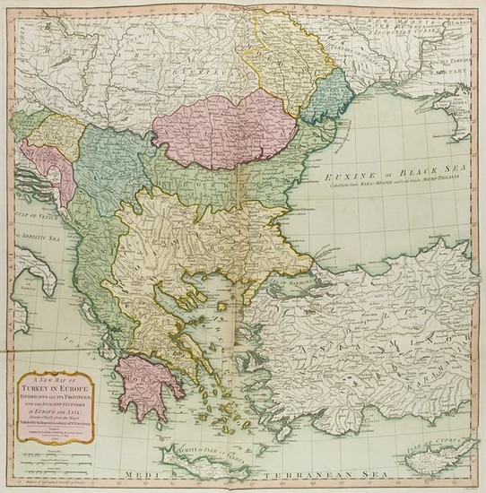
Enthält: Les Estats De La Couronne de Castille dans les Parties plus Septentrionales de L'Espagne ... v. Jean Somer(s) Pruthenus n. Nicolas Sanson d' Abbeville aus "Cartes generales de toutes les parties du monde". Paris Pierre Mariettes dat. 1652. Mit Meilenzeiger Titelkartusche mit Verlegeradresse. In der Platte sign. - Zeigt Galizien Asturien Leon das Baskenland mit dem Golf von Biscaya Valladolid und Burgos. 41 x 53 5 cm (45 5 x 60 cm). - Comitatvvm Hannoniae et Namvrci descriptio. Amsterdam Jansson 1647. Grenzkol. 39 x 50 cm (49 x 58 5 cm). - Gebräunt Randläs. - Totius Danubii cum Adjacentibus Regnis nec non Totius Graeciae et Archipelagi Novissima Tabula. Grenzkol. n. A. G. Böhme bei Homann Erben dat. 1766. Blattm. 49 5 x 59 cm. - Gebräunt angeschmutzt Randläs. - A New Map of Turkey in Europe divided into all its Provinces with the adjacent Countries in Europe and Asia. Kol. London Laurie & Whittle 1794. 61 x 60 cm (63 x 72 cm). - Tls. hinterlegte Läs. in Rändern u. Falzen.
View it on
Estimate
Time, Location
Auction House
Sammlung von 4 Kupferstichkarten.
Enthält: Les Estats De La Couronne de Castille dans les Parties plus Septentrionales de L'Espagne ... v. Jean Somer(s) Pruthenus n. Nicolas Sanson d' Abbeville aus "Cartes generales de toutes les parties du monde". Paris Pierre Mariettes dat. 1652. Mit Meilenzeiger Titelkartusche mit Verlegeradresse. In der Platte sign. - Zeigt Galizien Asturien Leon das Baskenland mit dem Golf von Biscaya Valladolid und Burgos. 41 x 53 5 cm (45 5 x 60 cm). - Comitatvvm Hannoniae et Namvrci descriptio. Amsterdam Jansson 1647. Grenzkol. 39 x 50 cm (49 x 58 5 cm). - Gebräunt Randläs. - Totius Danubii cum Adjacentibus Regnis nec non Totius Graeciae et Archipelagi Novissima Tabula. Grenzkol. n. A. G. Böhme bei Homann Erben dat. 1766. Blattm. 49 5 x 59 cm. - Gebräunt angeschmutzt Randläs. - A New Map of Turkey in Europe divided into all its Provinces with the adjacent Countries in Europe and Asia. Kol. London Laurie & Whittle 1794. 61 x 60 cm (63 x 72 cm). - Tls. hinterlegte Läs. in Rändern u. Falzen.

![Nicolas Sanson (Abbeville, 1600 - Parigi, 1667) [da] Mappa Mondo... Nicolas Sanson (Abbeville, 1600 - Parigi, 1667) [da] Mappa Mondo...](https://gcp-la8-storage-cdn.lot-art.com/public/upl/9/Nicolas-Sanson-Abbeville-1600-Parigi-1667-da-Mappa-Mondo_66210759e7e24-thumb-96042300_1713440602-6621075aea7b8.jpg)


![Nicolas Sanson (Abbeville, 1600 - Parigi, 1667) [da], Mappa Mondo o vero Carta Generale del Globo Terestre Rapresentato in due Planisferi. Roma: Gio. Iacomo de Rossi alla Pace, 1674. Nicolas Sanson (Abbeville, 1600 - Parigi, 1667) [da], Mappa Mondo o vero Carta Generale del Globo Terestre Rapresentato in due Planisferi. Roma: Gio. Iacomo de Rossi alla Pace, 1674.](https://gcp-la8-storage-cdn.lot-art.com/public/upl/9/Nicolas-Sanson-Abbeville-1600-Parigi-1667-da-Mappa-Mondo-o-vero-Carta-Generale-del-Globo-Terestre-Rapresentato_661858fdb3a25-thumb-88461500_1712871679-661858ffd7f98.jpg)


