Carte Des Nouvelles Decouvertes Au Nord de la Mer du Sud, Tant a l'Est de la Siberie et du Kamtchatka, Qua l'Ouest de la Nouvelle France
By Francois Santini, Ausgabe bei M. Remondini
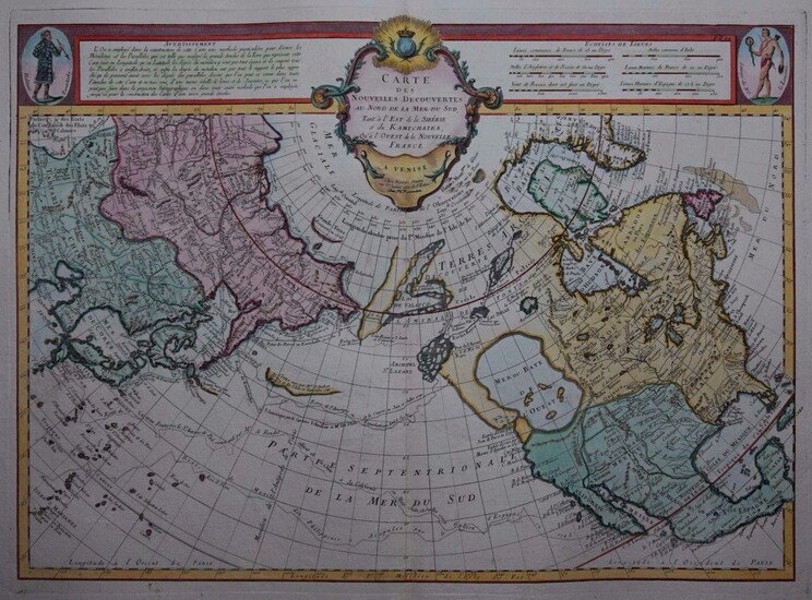
Es handelt sich hierbei um eine originale, kolorierte Kupferstich-Landkarte des nördlichen Pazifiks von Francois Santini bei M. Remondini aus dem Jahr 1784. *** Titel: Carte Des Nouvelles Decouvertes Au Nord de la Mer du Sud, Tant a l'Est de la Siberie et du Kamtchatka, Qua l'Ouest de la Nouvelle France *** Gebiet bzw. Ort: Der nördliche Pazifik - Nordamerika und Asien *** Kartograph: Francois Santini, Ausgabe bei M. Remondini *** Jahr: 1784 *** Größe des Plattenbereichs: 47 x 64 cm *** Technik: Kupferstich *** Zustand (Perfekt/ Sehr gut/ Gut/ Ordentlich/ Mäßig/ Schlecht): In gutem Erhaltungszustand *** Bemerkungen: Es handelt sich bei dieser seltenen Karte um ein Exemplar der von Francois Santini überarbeiteten Ausgabe der Karte des Joseph Nicholas Delisle, die den nördlichen Pazifik mit Nordamerika und Asien zu ersten Mal genauer zeigte. Die im Jahr 1752 erschienene Karte Delisles war ein kartographischer Meilenstein, da sie bis zu den Entdeckungen Cooks die umfangreichste Verbesserung in der Kartografierung dieses Gebiets darstellte. Die Karte berücksichtigte dafür die Entdeckungen und Erkenntnisse diverser russischer Expeditionen (u.a. von Tchirkow and Vitus Bering). Die vorliegende Karte zeigt den Nördlichen Pazifik mit Asien, Amerika und dem Nordpol als Zentrum. Sie kombiniert neue Entdeckungen mit älteren geographischen Hypothesen und Vorstellungen, so z.B. der großen "Bay of the West" in Nordwestamerika. Die russische Küstenlinie ist einigermaßen exakt dargestellt, wo hingegen die amerikanische Küste nördlich von Cape Mendocino sehr hypothetisch und größtenteils ungenau wiedergegeben ist. Die Karte wurde 1776 von F. Santini im "Atlas Universel dresse sur les meuilleures cartes modernes 1776" herausgegeben. 1784 verkaufte Santini die Platten an M. Remondini, bei dem auch das vorliegende Exemplar erschienen ist. Referenz: Mcguirk, Mer de l'Ouest, 163, Wagner 566, Lowery 660, Tooley #103. *** English description: This rare map is an example of Francois Santini's edition of Joseph Nicholas Delisle's map of the Northern Pacific Ocean, North America and Asia, including an interesting depiction of the "Bay of the West", it was published by M. Remondini in 1784. The Delisle map from 1752 was a cartographic landmark, that represented the most important improvements in mapping of this region prior to Cook. The map included the discoveries of a number of Russian explorers, including Tchirkow and Vitus Bering with many significant new land discoveries. This map shows North America and Russia arrayed from the North Pole. It is a fascinating combination of modern discoveries and earlier cartographic myths, including the Bay of the West and the discoveries of De la Fuca and d'Aguilar from the late 16th century. While the Russian coastline is shown with reasonable accuracy, the American coastline north of Cape Mendocino is still very hypothetical and largely incorrect. The map was prepared by the Venetian cartographer and publisher Francois Santini and first published in Santini's "Atlas Universel dresse sur les meuilleures cartes modernes 1776". In 1784 Santini sold the plates to M. Remondini, whose name appears on this example - indicating that this is the 2nd state of the map. The map measures 47 x 64 cm (platesize) and is in good condition. References: Mcguirk, Mer de l'Ouest, 163, Wagner 566, Lowery 660, Tooley #103. --- International buyers welcome. If you have any questions, please don't hesitate to ask. --- Auf Wunsch stellen wir Ihnen gerne ein kostenfreies Echtheitszertifikat aus --- If you wish, we will gladly provide a certificate of authenticity free of charge ---
Publication year: 1784
Vendor: Kunstantiquariat Andreas Senger
Buy Now on
By Francois Santini, Ausgabe bei M. Remondini
Es handelt sich hierbei um eine originale, kolorierte Kupferstich-Landkarte des nördlichen Pazifiks von Francois Santini bei M. Remondini aus dem Jahr 1784. *** Titel: Carte Des Nouvelles Decouvertes Au Nord de la Mer du Sud, Tant a l'Est de la Siberie et du Kamtchatka, Qua l'Ouest de la Nouvelle France *** Gebiet bzw. Ort: Der nördliche Pazifik - Nordamerika und Asien *** Kartograph: Francois Santini, Ausgabe bei M. Remondini *** Jahr: 1784 *** Größe des Plattenbereichs: 47 x 64 cm *** Technik: Kupferstich *** Zustand (Perfekt/ Sehr gut/ Gut/ Ordentlich/ Mäßig/ Schlecht): In gutem Erhaltungszustand *** Bemerkungen: Es handelt sich bei dieser seltenen Karte um ein Exemplar der von Francois Santini überarbeiteten Ausgabe der Karte des Joseph Nicholas Delisle, die den nördlichen Pazifik mit Nordamerika und Asien zu ersten Mal genauer zeigte. Die im Jahr 1752 erschienene Karte Delisles war ein kartographischer Meilenstein, da sie bis zu den Entdeckungen Cooks die umfangreichste Verbesserung in der Kartografierung dieses Gebiets darstellte. Die Karte berücksichtigte dafür die Entdeckungen und Erkenntnisse diverser russischer Expeditionen (u.a. von Tchirkow and Vitus Bering). Die vorliegende Karte zeigt den Nördlichen Pazifik mit Asien, Amerika und dem Nordpol als Zentrum. Sie kombiniert neue Entdeckungen mit älteren geographischen Hypothesen und Vorstellungen, so z.B. der großen "Bay of the West" in Nordwestamerika. Die russische Küstenlinie ist einigermaßen exakt dargestellt, wo hingegen die amerikanische Küste nördlich von Cape Mendocino sehr hypothetisch und größtenteils ungenau wiedergegeben ist. Die Karte wurde 1776 von F. Santini im "Atlas Universel dresse sur les meuilleures cartes modernes 1776" herausgegeben. 1784 verkaufte Santini die Platten an M. Remondini, bei dem auch das vorliegende Exemplar erschienen ist. Referenz: Mcguirk, Mer de l'Ouest, 163, Wagner 566, Lowery 660, Tooley #103. *** English description: This rare map is an example of Francois Santini's edition of Joseph Nicholas Delisle's map of the Northern Pacific Ocean, North America and Asia, including an interesting depiction of the "Bay of the West", it was published by M. Remondini in 1784. The Delisle map from 1752 was a cartographic landmark, that represented the most important improvements in mapping of this region prior to Cook. The map included the discoveries of a number of Russian explorers, including Tchirkow and Vitus Bering with many significant new land discoveries. This map shows North America and Russia arrayed from the North Pole. It is a fascinating combination of modern discoveries and earlier cartographic myths, including the Bay of the West and the discoveries of De la Fuca and d'Aguilar from the late 16th century. While the Russian coastline is shown with reasonable accuracy, the American coastline north of Cape Mendocino is still very hypothetical and largely incorrect. The map was prepared by the Venetian cartographer and publisher Francois Santini and first published in Santini's "Atlas Universel dresse sur les meuilleures cartes modernes 1776". In 1784 Santini sold the plates to M. Remondini, whose name appears on this example - indicating that this is the 2nd state of the map. The map measures 47 x 64 cm (platesize) and is in good condition. References: Mcguirk, Mer de l'Ouest, 163, Wagner 566, Lowery 660, Tooley #103. --- International buyers welcome. If you have any questions, please don't hesitate to ask. --- Auf Wunsch stellen wir Ihnen gerne ein kostenfreies Echtheitszertifikat aus --- If you wish, we will gladly provide a certificate of authenticity free of charge ---
Publication year: 1784
Vendor: Kunstantiquariat Andreas Senger


